Preservation 1891-Today
Preservation efforts for the 40 stones continue to mark those lines today.
They are the oldest monuments ever purchased by the United States government. They’ve been here for 232 years. That’s a long time.
-
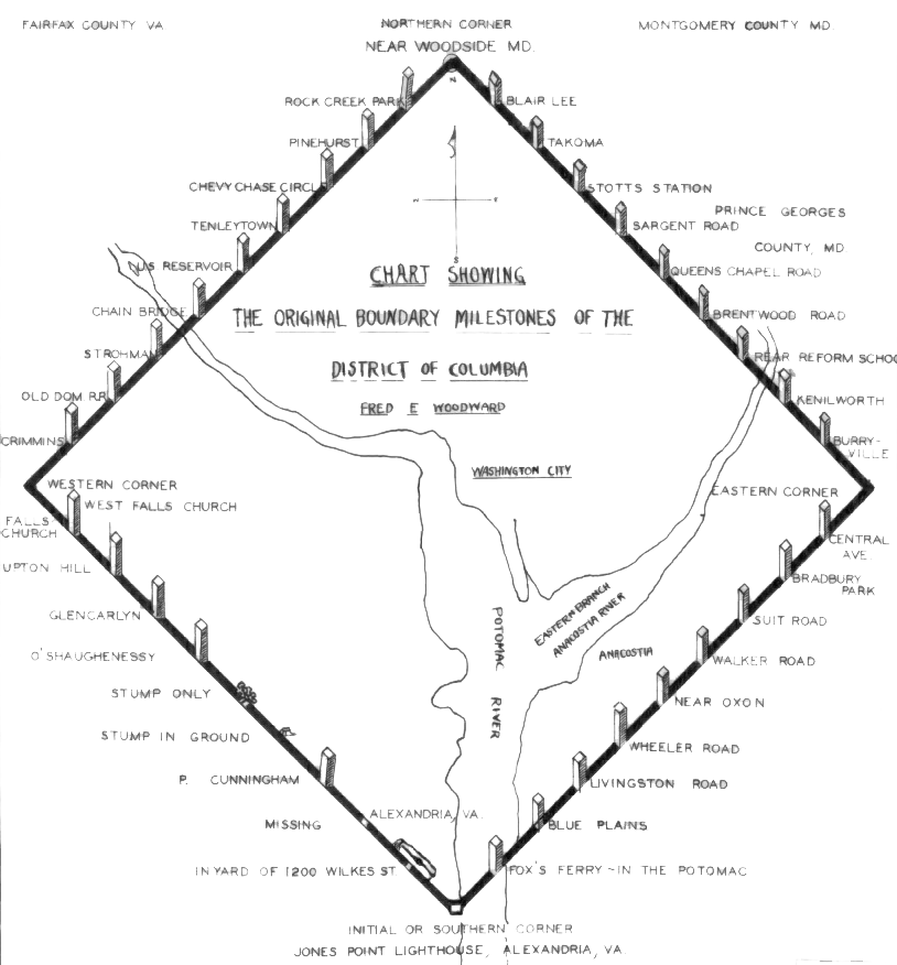
After President George Washington chose the Potomac River region as the site for the new national capital in 1790, surveyors (most notably Andrew Ellicott) laid out 40 sandstone markers to mark the territory by placing a boundary stone every mile.
The stones have four sides – facing inward towards DC (which read “Jurisdiction of the United States” and a mile number), facing outward (which show the name of the bordering state, either Maryland or Virginia), and two faces parallel to the boundary line (showing the year the stone was placed and the compass variance at that point).
-
The stones are the oldest federal monuments in the country and are listed on the National Register of Historic Places.
Many of the forty stones remain in their original places. Due to development in the area, the stones now stand in such places as a church parking lot, a road’s median, and at the bottom of a pipe at the Blue Plains Impoundment Lot.
Because of development pressures, many of the stones have been moved to locations that are more convenient.
-
The NCS has been involved in the preservation effort since the late 1970s and revitalized interest in the stones with our biannual fence restoration projects held between 2010 and 2012.
In 2014 and 2015, Daughters of the American Revolution, who originally erected the fences around the stones, renewed its boundary stone preservation efforts.
-
The stones that sit on the D.C./Maryland line were deemed the property of the D.C. Department of Transportation. But on the Virginia side, if you own the land, you own the stone.
D.C.’s 40 boundary stones were set in place at the behest of President George Washington in 1791 to designate the border of the nation’s capital. Like everything in America, there’s a story to the boundary stones. And, like everything in Washington, it’s a precarious, convoluted mess of politics, money and geography. (WTOP/Will Vitka, Dave Dildine)
DC Stones keeps WTOP up-to-date about the Boundary Stones
In 10 spots along the outskirts of Arlington, there sit seven chunks of sandstone enclosed by a small black perimeter fence. They lie in backyards, parking lots, even in the median of a street in South Arlington. Thousands of people walk or drive by them every day, most of whom are likely not aware of their significance or place in local and national history.
(WTOP/Staff, September 19, 2013)
Boundary Stone SE7, placed in 1792, was one of 40 (now 37) original federal monuments to mark the boundary of the “Territory of Columbia,” and was missing. Fortunately, engineer & historian Stephen “DC Stones” Powers saved the stone out of the rubble of a car accident. (WTOP/Grace Newton, June 9, 2024)
East Corner Boundary Stone 101st Fence Rededication.
The fence was first installed in 1916 and was painstakingly removed, restored, and placed back on the site by the District of Columbia Daughters of the American Revolution (DCDAR) and the American Society of Civil Engineers, National Capital Section who also cleared the site and rehabilitated the trail on the site.


